Charlotte County, surrounding area in severe thunderstorm watch
Published 4:28 pm Thursday, April 6, 2023
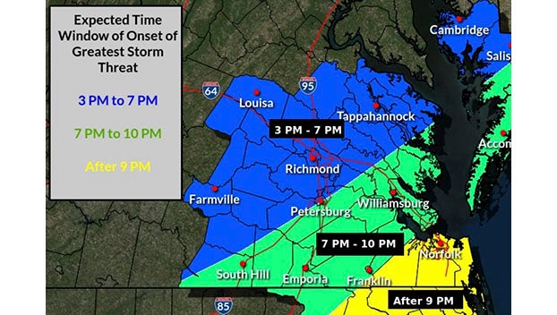
- A look at the latest data from the National Weather Service.
|
Getting your Trinity Audio player ready...
|
CHARLOTTE COURT HOUSE – Take precautions if you have outside plans tonight. The National Weather Service has placed Charlotte County, along with the surrounding area under a severe thunderstorm watch until 10 p.m.
The NWS issued the watch just before 3 p.m. A watch is issued hours in advance of a potential storm. It just means one is likely to occur in the area. A warning, on the other hand, means a storm is either happening right now or about to take place.
Over the last few days, a cold front moving through the midwest caused high winds and severe thunderstorms. That’s the front heading into our area. National Weather Service officials out of Wakefield say as that cold front moves into the Charlotte County region, it’ll mix with the warm air we’ve been experiencing this week. That mixture is what will trigger thunderstorms. NWS officials say the storms have the potential to produce wind gusts of up to 60 mph and possible some small hail, roughly the size of a marble.
Even after the threat of a severe thunderstorm clears later tonight, the system itself will stick around. Temperatures are expected to drop and there is a 100% chance of rain from 7 a.m. to 4 p.m. Friday. That’s going to bring a drop down to the low 60s during Friday day and low 40s, possibly high 30s Friday night.
On the plus side, it looks like the clouds at least, if not the cold, will move out of the region by Sunday. So far, it appears we’ll see sunny skies for Easter morning.

